OKOLIŠTE
Location
The Visoko Basin is situated 40 km northwest of Sarajevo. It has a size of 110 sq. km and represents a typical landscape of the "Polje"-type . The basin is crossed by the river Bosna and is 400–410 m above sea level. It is formed by Pleistocene river terraces and Para brown soils. The basin is encircled by Miocene mountains of up to 1000 m height. Its Middle Neolithic occupation is represented by the Kakanj group, and the Late Neolithic occupation by the Butmir group. Their typological ceramic sequence and the absolute chronology of this period is basically known thanks to the Bosnian-American excavations at the sites Obre I and II situated 10 km farther to the north (Benac 1973a; Benac 1973b; Gimbutas 1974; Sterud/Sterud 1974). Within the Visoko Basin and its lateral valleys about 15 Middle and Late Neolithic sites are known by surveys and earlier excavations (Perić 1995). The settlement mound of Okolište is located on a Pleistocene river terrace in the northern part of the Visoko Basin. Surveys at several Butmir sites like Obre, Donje Moštre, Zagrebnice and Butmir have shown that Okolište is by far the largest site in the Visoko Basin as well as among the whole of the Butmir group. The settlement measures approximately 7.5 ha, the thickness of the settlement strata amounts to up to 3 m. Other Butmir sites typically do not exceed a size of 3.5 ha. These differences in size seem to indicate a hierarchical settlement system in the Visoko Basin of the Late Neolithic and probably also hint at the development towards a more complex society.
Prospections in Okolište
At the beginning of the field work in Okolište, a drilling transect and a geomagnetic survey were carried out (Hofmann et al 2007, 53–63). The southern part of the settlement is overbuilt by the village Radinovići. The drillings showed that the thickness of the cultural layer varies between 1 and 3 m.The results of the geomagnetic and topographic surveys show a rectangular settlement area measuring approximately 330 by 270 m enclosed by an elaborate system of up to four parallel ditches .
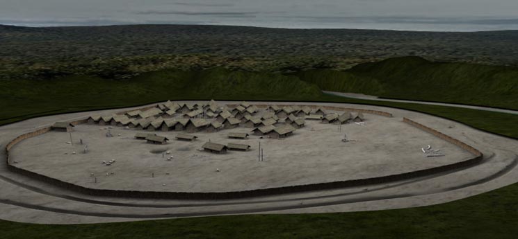 Okolište settlement 3d reconstruction
In the northwestern part of the site this fortification is divided into two strands, indicating considerable changes of the settlement size over time. Inside the enclosure are numerous northeast–southwest oriented houses, arranged in lines. They seem to be concentrated especially in the Northeast of the area, whereas farther in the South and West only isolated houses or smaller groups of them are visible.
Strategy of research
Until the end of the year 2007 eight areas with a size of 1260 sq. m have been excavated in Okolište, situated within the enclosure as well as in the area of the fortification . The selection of the excavation areas was based on the results of the geomagnetic survey. However, the excavations allow a more precise interpretation of the geomagnetic plan. The choice of the investigated areas originally rested on the assumption that the geomagnetic plan shows contemporaneous features . Thus it seemed possible to compare clearly divided coexistent households in regard to social differentiation and craft specialisation.Because the typological development of material culture as well as the absolute chronology of the Central Bosnian Neolithic is already known, whereas systematically uncovered settlement structures are still relatively rare in southeastern Europe, uncovering large areas was given priority in Okolište.
Interestingly, it turned out that the features visible in the geomagnetic plan are by no means all contemporaneous (cp. the following chapters). Rather, due to changes of the settlement size houses from different phases lie close to the surface of the settlement mound. This fact permits the investigation of the diachronic development of the settlement pattern and the material culture.The archaeological fieldwork in the Visoko Basin is combined with an extensive programme of investigations of the natural environment and the economic fundamentals of life in Neolithic time. Besides the analyses of the animal bones and the carbonized plant remains there are pedological and palynological investigations in the surrounding of the site Okolište and the Visoko Basin
(Kučan et al. 2006; Bittmann/Wolters 2007; Kučan 2007).
Fortification system
The fortification system of the settlement was excavated in three areas in the northern part as well as in one area on the eastern slope to a cut-off meander of the Bosna (excavation areas 2, 5, 6 and 7) . According to the results from area 2 it seems that at least two ditches existed at the same time, 3.5 and 4.5 m wide and around 1.3 m deep (Hofmann et al 2007, 69–73). At the inner side of the fortification a rampart and a palisade were uncovered.
Based on stratigraphical observations and a series of radiocarbon dates it is assumed that the fortification was constructed around 5200/5100 B.C. during the early phase of the settlement. Until 5000/4900 B.C. the ditch-system was filled in and renewed at least twice. The last renewal took place around 4900 B.C. After that, a gradual filling of the ditches can be observed.
Consequently, the fortification system was only used for a relatively short period of time and had been given up long before the end of the settlement around 4500 B.C. From the typological point of view the ceramics from the different phases of the fortification in Okolište represent late Kakanj- to Butmir II-material. However, the Butmir II-material is exclusively connected to the phase of the gradual filling of the ditches.During the campaign of the year 2006 area 5 situated a little farther to the West, where the two strands of the fortification cross each other, was excavated. One of the most important observations of this excavation is that the external strand is definitely older than the inner one. Thus, it can be stated that around 5000 B.C., already in a relative early phase, the settlement was reduced in size: from 7.5 to approximately 5.6 ha.